Plan Framework
Amenities & Infrastructure
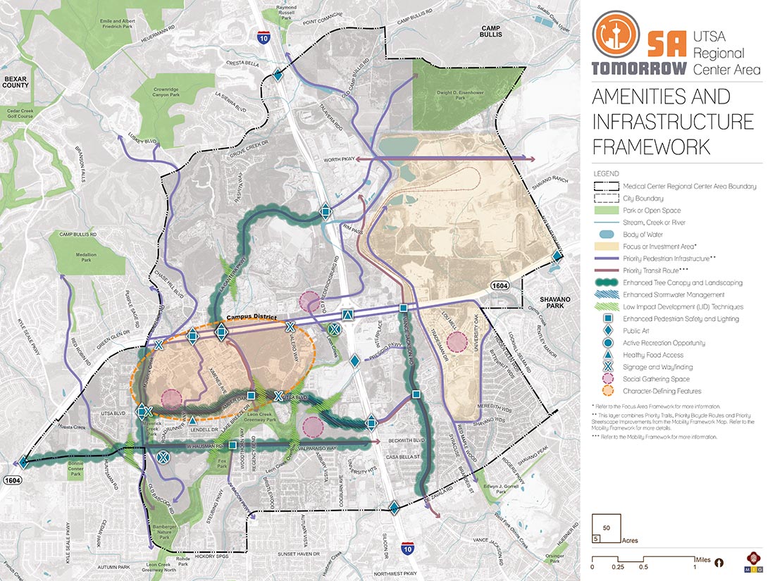
The map below highlights the Amenities & Infrastructure Framework recommendations identified for the UTSA Area Regional Center. Scroll down learn more about the vision for Amenities & Infrastructure in the Plan Area.
Introduction
As one of the fasted growing areas in the City, the UTSA Area Regional Center has attracted significant investment in recent years. Throughout the planning process, the community expressed a strong desire to ensure new development contributes to, and is well connected with, area amenities like recreation, open space, employment, and retail. The City has been supporting existing and new development in the area with recently improved streets and open space. Even with these recent investments, community members highlighted the need to further increase access to healthy food, as well as active and passive recreation.
Mobility improvements will help to encourage connectivity among the disjointed quadrants of the UTSA Area while providing tremendous opportunities for placemaking. Well-defined pathways, wide sidewalks, a robust tree canopy, green infrastructure, enhanced lighting, public art, wayfinding signage, and branding will help to cultivate a stronger sense of place and foster a cohesive user experience. The addition of public art installations has been recommended as a method to help define trail access points, highlight non-motorized routes, and signal entry into a neighborhood, district, or campus.
The UTSA Area is unique in its varied and sometimes pronounced topography. Natural drainage ways, steep slopes, and areas of dense vegetation mark the region. The result has been a series of concentrated developments that take advantage of high ground, flatter sections of parcels, and areas with less native vegetation. Additional concentrated investment will likely occur along similar patterns and take advantage of major corridors. Enhanced stormwater management features, low impact development (LID) techniques, and clustered developments that use existing drainage to filter stormwater runoff pollutants and protect and preserve green space, creeks, and rivers have been identified as appropriate approaches to better integrate future developments into the area’s natural amenities.
Amenities and Infrastructure Recommendations
Recommendation #1:
Increase the amount and connectivity of natural and built green infrastructure in a manner which increases active and passive recreational opportunities.Stakeholders within the UTSA Area have expressed a strong desire for protecting, enhancing, and augmenting the system of greenways, trails, and natural drainage ways. As new development occurs, these natural systems should be further augmented with low impact development techniques and integrated green infrastructure in and along parks, open spaces, and roadways. Active recreation needs can largely be met with trails and multi-use pathways that connect more passive recreation opportunities with natural areas, places to sit and gather, picnic areas, and viewing/observation features.
The combination of major highway infrastructure, large active quarries, varied topography, and curvilinear streets make the UTSA Area somewhat difficult to navigate. In addition, there is not a cohesive sense of place across the Regional Center. Stakeholders engaged in the planning process highlighted many opportunities to strengthen the area’s identity through the introduction of additional public art, gateway features, and signage in order to address barriers created by major infrastructure and better knit the area together.
UTSA Area stakeholders expressed strong desires for a greater variety of healthy food options. These could potentially include community gardens and orchards, farmers’ markets, road side food stands, food cooperatives, smaller neighborhood grocers, and more traditional full-service grocery stores. Another concept to pursue and promote is community-supported agriculture (CSAs), in which consumers receive fresh food directly from farms and ranches via a subscription service.
With the exception of the actual UTSA Campus, the southern half of the UTSA Area Regional Center currently lacks common gathering spaces to host community events and programs. Stakeholders promoted the idea of adding at least one community gathering space to existing development in the southwest and southeast quadrants of the plan area. These social gathering spaces should support existing and new development and include parks, plazas, and other flexible outdoor spaces that can host formal and informal community gatherings and events.
Amenities and Infrastructure Components
Parks, Trails and Open Space
While the UTSA Area has several existing parks and natural greenways, many of the largest parks and open spaces are on the edge or outside of the plan area, making these amenities difficult to access for many residents.
Specific priority locations for additional and enhanced parks and open spaces are:
- Northwest Quadrant
- Enhanced tree canopy and low impact development along La Cantera Parkway
- Improved pedestrian connections to nearby Medallion and Crownridge Canyon Parks
- Northeast Quadrant
- Improved pedestrian and bicycle connectivity to Eisenhower Park
- Consideration of future parks and open space when quarries are retired
- Southeast Quadrant
- Enhanced tree canopy along Vance Jackson Road
- New community gathering space to serve existing residents and employees
- Southwest Quadrant
- Low impact development and greenway enhancements along and connecting to Leon Creek
- New trail and/or multi-use pathway connection along Babcock Road/Maverick Creek
- New community gathering space southeast of the UTSA Campus
Arts and Cultural Amenities
The community expressed a strong interest in new healthy food options, outdoor gathering spaces, and better connections to the UTSA Campus, which was highlighted as the most important character defining feature of the Regional Center other than the natural topography and drainage spread throughout. The majority of these opportunities were identified in the southern half of the plan area to serve existing residents, but it will be important that new development in the northern portions of the UTSA Area include similar community amenities to keep pace with the increasing demands of new growth.
Green Infrastructure and Low Impact Development
As the UTSA Area accommodates more people and buildings, the importance of parks, open space, and trails will grow. In addition to protecting valuable natural areas that exist today, streets, parking lots, sidewalks, and pathways represent an opportunity to use space for more than just transportation and recreation. They are places that can accommodate trees, functional landscaped areas to soak rain water into the ground, and stormwater infastructure that include native plants and potentially art. Green infrastructure and low impact development should be incorporated into the UTSA Area landscape at multiple scales, including individual site developments, along multiple street segments as part of street reconstructions, or through coordinated investments throughout a new development. Examples of green infrastructure and low impact design tools that may be used in the UTSA Area include those listed below. The National Association of City Transportation Officials (NACTO) Urban Street Stormwater Guide provides guidance and examples of green infrastructure incorporated into streets, such as:
- Alternative street designs
- Street trees
- Bioswales and vegetated swales
- Rain gardens
- Bioretention curb extensions and sidewalk planters
- Permeable pavement
- Bioretention cells
- Water quality swales
- Grassed infiltration areas
- Interrupted runoff flow paths
- Sidewalk trees and tree boxes