Plan Framework
Mobility
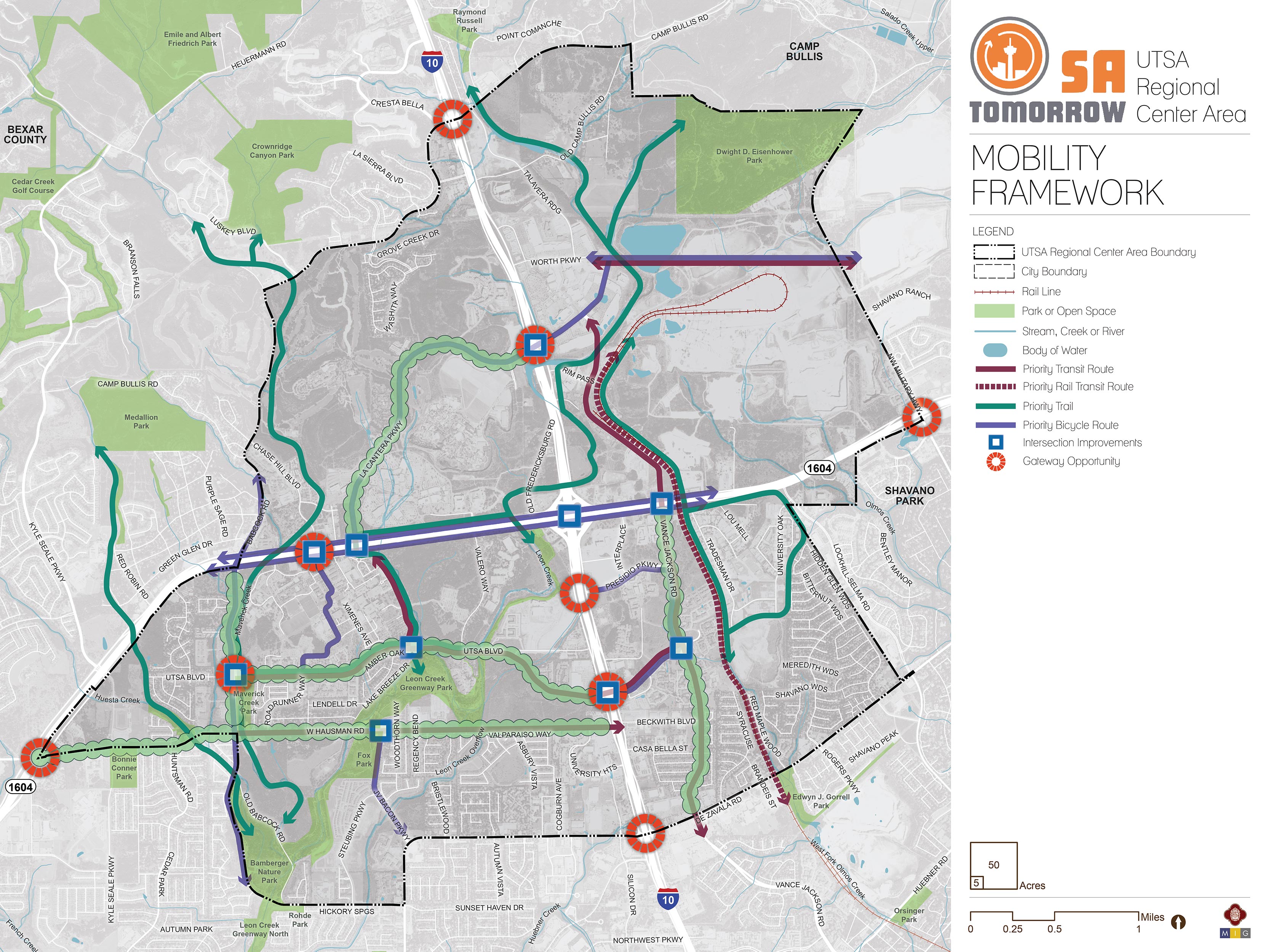
The map below highlights the Mobility Framework identified for the UTSA Area Regional Center. Scroll down to learn more about the vision for Mobility in the Plan Area.

Background and Vision
In 2016, the City of San Antonio adopted the SA Tomorrow Multimodal Transportation Plan, to make our city’s transportation system “sustainable, safe, convenient, efficient, and inclusive of all modes.” The plan adopted by City Council established “a shift in focus from moving vehicles to moving people,” in order to manage traffic congestion, and improve transportation choices. The plan identified two primary and interdependent methods for managing future traffic congestion:
- Develop a land use pattern and policy to promote local trips
- Provide transportation options in addition to vehicles that connect Regional Centers
The SA Tomorrow Multimodal Transportation Plan acknowledged that we cannot build our way out of congestion, and that the Comprehensive Plan, and associated land use plans, are a primary opportunity to improve mobility in San Antonio. By welcoming more people to live, work and play in urban centers, regional centers, and transit corridors, we can shorten trip lengths, offer more transportation choices, and improve quality of life.
The combined costs of housing and transportation (commonly referred to as H+T) are often a large portion of a household’s budget, with experts recommending the combined total not be more than 45% of household income. In the Greater San Antonio Region that total on average is 53%. Walkable communities that provide great transit options can reduce the household transportation costs for the average person, because if people have an alternative to driving alone, transportation costs can be stable even when gas prices rise. By providing transportation options, as some people choose to go to their destination on foot, bicycle or transit, the number of cars on the road will be minimized, reducing traffic delay for those people that choose to drive.
As a regional destination featuring a collection of the region’s most significant institutions and corporate partners, the UTSA Area Regional Center is full of diverse economic opportunity and innovation. The UTSA Area Regional Center Plan aims to prioritize investments in the community that provide more opportunities to age in place and live, learn, work, and play at all stages of life, while leveraging unique attributes of the UTSA Area. Multimodal infrastructure investments to transform streets into great public places, such as additional bicycle and pedestrian resources, as well as VIA Metropolitan Transit rapid transit investments, are needed to better serve existing residents, accommodate new residents, and effectively connect the UTSA Area to the greater San Antonio region.
Supporting a “dynamic university district” is central to the vision for the UTSA Area Regional Center Plan. The previous focus on prioritizing automobiles disconnects the district and leaves many parts of the area with limited bike facilities, incomplete sidewalks, few crosswalks, and poor access to the amenities of the area. With a focus on improving the conditions for people walking and bicycling, the UTSA Area will become a healthy and connected community where local residents can access destinations near their homes without having to drive. Improved neighborhood connections to nearby trails, such as the existing Leon Creek Greenway and Huesta Creek Greenway and the planned northern extensions connecting Leon Creek Greenway to Salado Creek Greenway at Eisenhower Park will provide enhanced connections between the four quadrants of the plan area. The system of trails will provide safe and easy access for pedestrians and bicyclists within the UTSA Area Regional Center and into the Northwest Community Plan Area.
Infrastructure such as sidewalks, streetscaping, and complete streets will also support transit usage to and from this area, allowing pedestrians last mile connections between transit stations and their destination. VIA Metropolitan Transit’s Primo and Rapid Transit Corridors are expected to provide frequent, reliable service, including a north-south connection, to better connect the UTSA Area to the economic activity of downtown and the South Texas Medical Center.
UTSA Area Regional Center’s Mobility Needs
The UTSA Area Regional Center has grown to become a critical economic and educational destination and is continuing to emerge as a center of activity, providing opportunity to emphasize access and mobility solutions. Key transportation needs identified for this sub-area include the following:
- Safety of the transportation network for all users, but especially pedestrians and bicyclists;
- Multimodal improvements focused on the transformation of the mobility network to better serve the combination of people choosing to walk, bicycle, take transit, rideshare, or travel in their own vehicle;
- Better connection of the UTSA Area Regional Center area with the broader San Antonio area; and
- Reduction of congestion hot spots for automobiles, freight, and transit vehicles.
To address the transportation needs in the UTSA Area, a set of high-level recommendations has been developed to address those needs, and a set of strategies have been identified to implement the recommendations through projects, policies, and partnerships. These recommendations and strategies are indicated on the Mobility Framework Recommendations map. These mobility recommendations will be further refined in a coordinated manner with the City’s Department of Transportation and Capital Improvements (TCI) and other relevant partners such as Texas Department of Transportation (TxDOT), VIA Metropolitan Transit (VIA), and the Alamo Area Metropolitan Planning Organization (AAMPO).
Recommendation #1:
Continue Implementing the San Antonio Vision Zero Action Plan.The City of San Antonio’s Vision Zero initiative aims to achieve zero fatalities on the community’s roadways and improve roadway safety for all users, whether driving, bicycling, or walking. The Vision Zero initiative evaluates and makes recommendations to improve safety in Severe Pedestrian Injury Areas (SPIAs), locations where two or more crashes close together have resulted in severe pedestrian injuries. Potential tools for improving pedestrian safety in Severe Pedestrian Injury Areas include Leading Pedestrian Intervals, Medians, and Pedestrian Crossing Islands based upon analysis of the unique factors that contribute to crashes in each location and depending upon the results of engineering assessments. Another approach to improve safety involves dedicating more space in the roadway to bicyclists and pedestrians. From new ways to protect bicycle lanes with separated barriers such as bollards, to landscaping and planters and raised medians, San Antonio has many available tools to improve pedestrian and bicycle safety. The City of San Antonio Vision Zero Action Plan lists additional tools for improving pedestrian and bicycle safety.
The UTSA Area has a number of opportunities for improving mobility and safety, especially for pedestrians. In particular, the 2018 San Antonio Severe Pedestrian Injury Areas Report (pages 39-40) identifies a Severe Pedestrian Injury Area (SPIA) within the UTSA Area Regional Center that should be a priority for study and investment is UTSA Boulevard from Roadrunner Way to Ximenes Avenue.
Additional analysis of pedestrian, bicycle, and vehicle crash data, along with community input, also identified additional points of conflict between people and vehicles that should be studied for future improvements. Major highways, such as I-10 and Loop 1604, and their associated frontage roads, create barriers for many pedestrians and bicyclists. The unwelcoming environment of fast speeds and limited amenities limits travel options for those walking or bicycling. Major roadways, like Babcock Road, UTSA Boulevard, and Vance Jackson Road have insufficient accommodations and less than ideal conditions for pedestrians and bicycles to travel on and cross safely. In addition, numerous driveways create many potential conflict points between automobiles, pedestrians, and bicycles. Employing strategies to reduce these points of conflict can increase safety in the study area.
Investments that focus on safety, such as the Vision Zero tools listed above, can have a significant positive impact throughout the UTSA Area, and especially in these identified conflict areas. Reducing speeds in appropriate places can also greatly improve safety for all users, by reducing the likelihood and intensity of crashes.
Recommendation #2:
Complete the multimodal layered network and trail system and work with partners to establish new connections.Multimodal and connected networks are key aspects to providing mobility for all users, regardless of ability or financial status. Transit improvements ensure areas are accessible while bicycle and pedestrian infrastructure provide last-mile connections to and from transit and key destinations. Urban design elements, such as driveway relocation, street calming, and complete streets, further support these improvements while providing safe and inviting spaces.
Complete Streets
Complete streets are envisioned for the UTSA Area, providing safe road designs for vehicles, pedestrians, and cyclists alike. The following streets are recommended for TCI to study for complete streets improvements:
- Babcock Road from Loop 1604 to De Zavala Road;
- UTSA Boulevard from Babcock Road to Vance Jackson Road;
- Vance Jackson Road from Loop 1604 to De Zavala Road; and
- Hausman Road from Babcock Road to I-10. (Significant improvements to Hausman Road were completed under the 2012 bond program, with elements of a complete street that include a multi-use path, a bike lane, sidewalks, and curbs. The UTSA Area Planning Team and community stakeholders would like to see streetscaping improvements along this stretch of road to encourage the use of transit and support walking and bicycling.)
These streets will also connect to recreational trails and parks, such as the existing Leon Creek Greenway and Huesta Creek Greenway and the future northern extensions connecting Leon Creek Greenway to Salado Creek Greenway at Eisenhower Park.
Priority Streetscape Improvements
Streetscape improvements are recommended for roads that primarily serve local residents and students, such as:
- Babcock Road from Loop 1604 to De Zavala Road;
- UTSA Boulevard from Babcock Road to Vance Jackson Road;
- De Zavala Road from I-10 to Lockhill Selma Road;
- Vance Jackson Road from Loop 1604 to De Zavala Road; and
- La Cantera Parkway.
A vision for these corridors is one where people walking, biking, taking transit or rideshare, or driving bring street-level activity to create safer and more vibrant streets.
Priority Trails
Key trails nearby or within the UTSA Area, like the existing Leon Creek and Huesta Creek greenways, and the planned northern extensions connecting Leon Creek Greenway to Salado Creek Greenway at Eisenhower Park, provide critical continuous arteries of separated pedestrian and bicycling infrastructure network, connecting numerous parks, retail locations, schools, and libraries. The critical access points to these regional amenities provide opportunities to improve connections for people walking, strolling, or bicycling with deliberate side paths or on-road infrastructure like crosswalks, sidewalks, and bicycle facilities.
Preferred Bicycle Routes
In many parts of the UTSA Area, bicyclists currently ride adjacent to mixed-traffic on high volume roads. Additional bike infrastructure, such as designated lanes, is highly recommended where feasible and as part of complete streets and other improvement projects. These measures will improve riding conditions for today’s commuters and welcome newer, less confident bicyclists, otherwise unaccustomed to riding alongside vehicles.
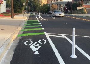
Based on input from the UTSA Area Planning Team and other community stakeholders, the Plan identifies preferred bicycle route improvements including Babcock Road from Bamberger Nature Park to north of Loop 1604, JV Bacon Parkway, Brenan and Brackenridge Avenues through the UTSA Campus, the Loop 1604 Frontage Roads throughout the plan area, La Cantera Parkway, as well as the Presidio Parkway/Vance Jackson Road/UTSA Boulevard loop on the east side of I-10. Corridors identified for complete streets along Babcock Road and Vance Jackson Road would also incorporate cycling infrastructure as a component of the design based on future studies by TCI to determine feasibility and the types of facilities needed. Recent additions of multi-use paths and bike lanes along UTSA Boulevard and Hausman Road have created improved conditions for cyclists, pedestrians, and vehicles alike; the possibility of extending these paths should be studied as a means of increasing system safety and connectivity throughout the UTSA Area.

The new Bike and Pedestrian Trail along S. Flores Street in San Antonio provides protected bicycle and pedestrian access to the community.

Bicycle parking and bikeshare integrated with Denver Union Station, CO.
Recommendation #3:
Alleviate congestion with multimodal solutions including targeted interventions for more efficient transit operations.Shifting users from driving alone to alternative modes of transportation can alleviate congestion along a corridor or within an area. This becomes more viable when alternatives are convenient, such as through improved access to transit and pedestrian-friendly infrastructure. This strategy directly supports the community's, City’s, and VIA’s goals and objectives, improving access to key destinations, decreasing vehicle miles traveled, and increasing the area’s walkability. To support growth and continue the vibrancy of the region’s economic centers, the community needs easy, reliable, and congestion-proof choices for traveling to and from work, school, and key destinations.
While congestion can be viewed as a sign of economic health, delays caused by congestion waste valuable time and create transportation emissions that reduce air quality. The transportation industry has learned ‘we cannot build our way out of congestion’, however a series of targeted operational and multimodal interventions can provide more travel options and reduce the demand on our roadways. Specifically, transit delays can be reduced with key investments that reduce congestion and conflict zones. These improvements, paired with other VIA Metropolitan Transit investments in service, can help make transit a more attractive travel option. This recommendation is responsive to the community’s stated Connectivity and Mobility goal which is to “Provide enhanced connectivity within the UTSA Area, with options for mobility beyond the automobile, while addressing congestion management and travel efficiency throughout the area for all modes and uses”.
Key improvements that could increase transit mobility include peak hour or school zone bus-only lanes that give priority to buses in times of peak traffic; queuing jump traffic signals that allow buses a chance to get ahead of the traffic; special event priority lanes that prioritize buses during traffic surges of planned events; and bus bulbs to allow buses to pick up passengers without entering/exiting traffic. Studies will need to be conducted to determine the appropriateness for each strategy for the areas of local congestion.
As indicated on the Mobility Recommendations Map, priority locations for more study include:
- De Zavala Road from Autumn Vista Street to Vance Jackson Road;
- I-10 Northbound Frontage Road at Loop 1604; and
- Loop 1604 Frontage Roads from Vance Jackson Road to La Cantera Parkway.
Recommendation #4:
Support VIA Metropolitan Transit Rapid Transit Corridor service by prioritizing transit supportive policies and infrastructure near transit stations.A future VIA Rapid Transit Corridor is anticipated to operate north-south on I-10 and Fredericksburg Road, requiring prioritized transit supportive policies and infrastructure, such as reduced parking requirements, and cohesive networks of sidewalks, crosswalks, and curb ramp improvements to provide safe connections to the transit line for people walking, bicycling, or getting dropped off in a vehicle.
Providing last mile connections between transit and key destinations, such as jobs and public spaces, improves mobility throughout the area while supporting walkability and safety for all transportation users. These improvements are outlined by the community’s goals and objectives for the UTSA Area Regional Center and are applicable to the future rapid transit corridor following the I-10 Frontage Road to UTSA Boulevard, through the UTSA Campus, and along La Cantera Parkway to the entrance of The RIM Shopping Center. Key components of VIA’s approach for making a place transit-supportive are streets designed for pedestrians, improving the safety of all users, and supporting compact, mixed-use developments that provide access to a variety of services reachable on foot.
Every person that gets on or off a bus or other transit vehicle is a pedestrian. Safe, comfortable and direct access to transit for people walking or biking to a transit station or stop will improve their experience as a transit rider and will increase the number of people choosing walking, bicycling, and taking transit as their preferred travel choice. These improvements also contribute to the overall quality of neighborhoods and communities.

Mobility Concepts
The recommendations in this plan will help create a user-friendly multimodal network that provides access to amenities; links UTSA Area residents, students, and employees to the greater San Antonio area; and, supports planned activity centers and land uses. The general concepts below serve as guiding principles for the more detailed Mobility Recommendations in the UTSA Area Regional Center Plan.
Complete Streets
In September 2011, San Antonio adopted a Complete Streets Policy (Ordinance 2011-09-29-0795) which encourages street designs that take into account all users and accommodate all ages and abilities including children, older adults, and persons with disabilities. This approach to street design “supports pedestrian and bicycle-oriented neighborhoods; promotes healthy living, fitness, and activity; enhances the economic vitality of commercial corridors and districts; and maximizes the benefits of investment in public infrastructure.” Not all complete streets have to be the same; the function of the road, level of traffic by mode, and adjacent land use and intensity will all be used to help determine road type and design features. Complete streets are envisioned for the UTSA Area, providing safe road designs for vehicles, pedestrians, and cyclists alike, while managing stormwater runoff onsite to protect the creeks and aquifer from pollutants.
Complete street studies and subsequent implementation should take into account best practices from guidance provided in the National Association of City Transportation Officials (NACTO) Design Guidelines, and NACTO Transit Street Design Guide for roadways that will include VIA Primo or Rapid Transit Corridor Service. Complete improvements should also include lighting, functional native landscaping, and green infrastructure where possible, and other placemaking features such as artistic elements. Implementing these policies and projects will ensure all people, regardless of income or ability, can access high-quality transportation services and can live car-free and access services, jobs, and recreation.
Resources that readers may use to visualize or understand the variety of tools available for improving pedestrian and bicycle safety and comfort may consider the following:
Priority Bicycle Routes and Streetscape Improvements
Protected bicycle facility in Bethesda, Maryland
Creating a Regional Center that encourages walking and biking with convenient, safe, and comfortable options will require an integrated network of pedestrian and bicycle routes along with well-designed streets in key activity areas and on the busiest corridors. Today, there are gaps in the multimodal system serving the UTSA Area, especially for people wishing to walk or bike. This Plan focuses on completing or enhancing sidewalk and bicycle networks and recommends new connections that will help people more safely and comfortably access existing amenities and destinations as well as planned mixed-use areas and improved corridors.
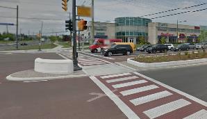
Improved Pedestrian Crossings
Safety is central to planning for the UTSA Area’s development as an accessible multimodal regional center. Analysis of previous pedestrian crashes, along with community input, has identified intersections and road segments most in need of study for pedestrian crossing or other safety improvements. Improved access to VIA service is also a key factor guiding pedestrian safety studies and investments.
Dedicating more space in the roadway to bicyclists and pedestrians by adding landscaped, buffered sidewalks along the roadway can improve the level of comfort for vulnerable users. Adding dedicated space for sidewalks results in a 65-89% reduction in crashes involving pedestrians walking along roadways, according to the FHWA. Bicycle and pedestrian facility design and materials have advanced considerably over the last decade. Many of San Antonio’s peers have tested and reported the results of new applications. From new ways to separate bicycle lanes with LED lit bollards, to landscaping and planters or raised medians or lanes, San Antonio has many options to implement the safety strategies in a way that meets the goals of the UTSA Area Regional Center Plan to improve safety on the transportation system and improving walkability.
Resources to implement strategies for pedestrians and bicycles can be sourced from the City of San Antonio Vision Zero Action Plan, as well as national resources such as the NACTO Design Guide to Transit Corridors. For resources on proven approaches to crash reduction, see:
- The FHWA Crash Reduction Factor Toolbox;
- National Highway Traffic Safety Administration’s Countermeasures That Work: A Highway Safety Countermeasure Guide for State Highway Safety Offices, Eighth Edition, 2015. Washington, D.C.: U.S. Department of Transportation. 2015;
- NCHRP Report 500 Volume 18: A Guide for Reducing Collisions Involving Bicycles;
- Crash Modification Factors Clearinghouse;
- FHWA Proven Safety Countermeasures. Federal Highway Administration, Office of Safety, Washington, DC, 2012;
- Handbook for Designing Roadways for the Aging Population. Federal Highway Administration, Office of Safety, Washington, DC, 2014;
- Separated Bike Lane Planning and Design Guide; and,
- The NACTO Urban Bikeway Design Guide (part of the Cities for Cycling initiative).
Frequent, Reliable, and Accessible Transit
Providing great transit service and a walkable environment allows users to choose travel options besides driving alone - alleviating a primary cause of congestion. Supporting alternative modes of transportation provides the community with easy, reliable, and congestion-proof choices for traveling to and from work, school, and key destinations and helps to fulfill the UTSA Area’s Connectivity and Mobility goal statements:
- “Ensure that vehicular traffic flows as smoothly as possible within the existing roadway network and traffic signal system;” and
- “Encourage transit as a mode of choice for residents and employees in the area by supporting transit service, frequency, safety, comfort, and infrastructure.”
These strategies also alleviate congestion along corridors within the community; this becomes more viable when alternatives are convenient, such as through improved access to transit and pedestrian-friendly infrastructure.
VIA’s Rapid Transit Corridors will create additional transportation choices in the area with new investments in very frequent transit service that quickly move people to their destinations. This additional transit service will provide more direct connections between the UTSA Area, the South Texas Medical Center, and Downtown. Studies are determining the exact routing and phasing of construction.
Complete streets and placemaking investments near transit corridors and access points are important to improve people’s ability to utilize transit through safe and pleasant community connections. In addition, future transit investments should be supported by transit supportive policies and infrastructure, such as reduced parking requirements, and a cohesive network of sidewalks, crosswalks, and curb ramp improvements that can provide safe connections to the transit line for people walking, bicycling, or getting dropped off in a vehicle.

Linked Mobility and Land Use
As communities evolve and grow, so do the demands on the mobility system. The location and type of growth in an area or along a corridor help determine the demand on the transportation network and viability of various transportation options. Likewise, transportation helps shapes the desirability and type of development in an area. Aligning this relationship shapes future development and growth patterns and directly supports the community’s goals and objectives of improving walkability, increasing access to transit, and enhancing access to economic areas and other key destinations. Such alignment of land use and mobility also helps implement VIA’s 2040 Strategic Plan for Station Areas, supporting transit-supportive land use surrounding transit stations.
As the UTSA Area Regional Center adds residents and employees based on the updated land use plan, impacts on the mobility needs of these new people and those of the current residents, students, and employees need to be considered. Land uses encouraging mixed-use and higher density developments are recommended along UTSA Boulevard, La Cantera Parkway, Vance Jackson Road, Hausman Road, and Babcock Road. With these more intense land uses, these major roadways can anticipate additional pedestrians, bicyclists, transit riders, cars, and freight delivery trucks of various sizes. Studies will need to determine common paths and volumes of pedestrian, bicycle, automobile, transit, and freight travel to ensure the area has sufficient infrastructure and careful prioritization of modes to help people safely reach their destinations.
Gateway Opportunities
Gateways display pride in a local area and welcome residents and visitors with art and architectural elements which reflect area history and culture. To build on the strong community identity already associated with the UTSA Campus and regional destinations like La Cantera and The RIM, several places within this sub-area provide opportunities for unique gateways. Along the northern portion of the plan area, a gateway at I-10 and La Cantera Parkway could welcome visitors and residents and provide cohesion across the quadrants of the Regional Center as it is divided by two major highways. In addition, a gateway at I-10 and UTSA Boulevard would help enhance the identity of the area.
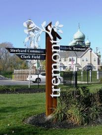
The Gateway Sign for Tremont, a neighborhood in Cleveland, Ohio.