Plan Framework
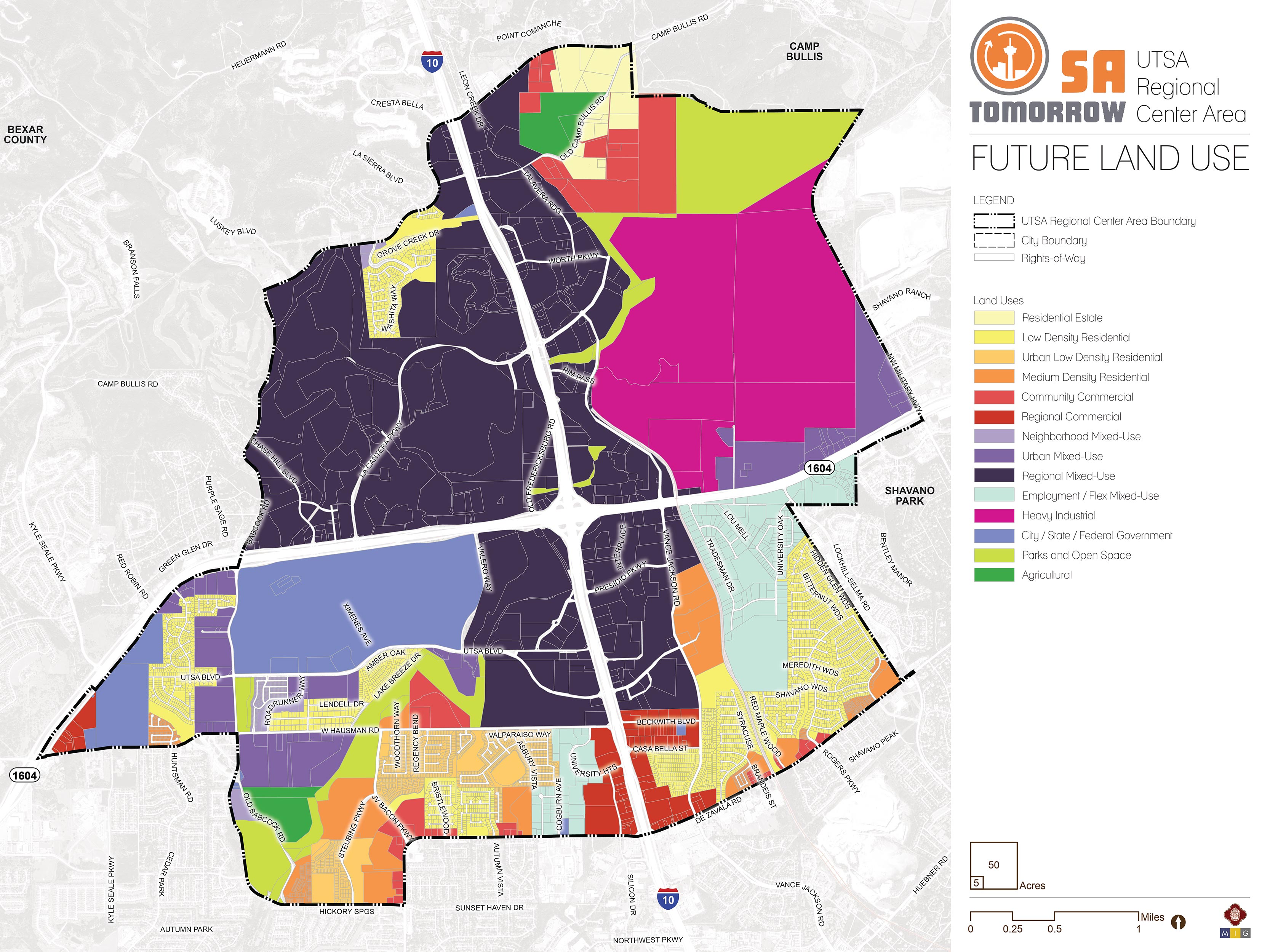
Land Use

The UTSA Area Regional Center future land use plan supports the SA Tomorrow Comprehensive Plan, Multimodal Transportation Plan, and Sustainability Plan, draws on recommendations from the SA Corridors Strategic Framework Plan, and implements the Vision, Goals, and Plan Framework for the UTSA Area. The land use plan encourages growth and increased density at various scales in mixed-use centers and focus areas, and along key transit and community corridors. It provides opportunity for higher density, mixed-use development associated with the major highways, but also preserves the character and form of existing neighborhoods.
The following sections describe the general land use patterns of the UTSA Area Regional Center. Recommendations for implementing the land use plan follow. Finally, the full catalogue of land use categories (including descriptions and allowable zoning districts) adopted in the Unified Development Code (UDC) is included for reference.
Residential Areas
Residential areas in the UTSA Area Regional Center are found generally around the edges of the Regional Center, with the highest concentrations located between Hausman Road and De Zavala Road on the west side of I-10, and a large area north of De Zavala Road between I-10 and the plan boundary near Lockhill Selma Road . The residential land in this plan area covers the spectrum of densities, including Residential Estate, Low Density Residential, Urban Low Density Residential, and Medium Density Residential.
Residential properties in the northeast portion of the planning area, near Camp Bullis, are designated as Residential Estate, reflecting existing patterns of use and suitable development near the base. The majority of the single-family areas in the Regional Center are designated as Low Density Residential, allowing and encouraging these areas to retain their current character and form.
Certain neighborhoods south of Hausman and north of De Zavala have been designated as Urban Low Density Residential. This is due to a more compact development pattern in these areas, and to the need for a broader variety of housing options in the UTSA Area Regional Center. Urban Low Density Residential areas accommodate a broader range of residential development forms, such as duplexes, compact lot single-family units and bungalow courts. The need for more housing options and for increased opportunity for first time home buyers has been identified as a need in this area.
Medium Density Residential is found in several places within the planning area, including along major arterial roadways such as Vance Jackson Road, JV Bacon Parkway, and De Zavala Road. These areas have existing multi-family developments, including townhomes, fourplexes, and medium- to large-scale apartment complexes. They often serve as a transition between major thoroughfares or commercial areas and lower density residential uses.
Mixed-Use Centers and Corridors
In addition to preserving the character of lower density residential neighborhoods, the land use plan also encourages more dense and intense land uses in appropriate areas including mixed-use centers, designated focus areas, and primary corridors. Each mixed-use area should have different qualities, design, and intensity based on surrounding uses, the type of the roadways in the area, and the amount of available land. The land use plan accounts for this by utilizing three different mixed-use categories, each of which encourages a different mix of allowable uses, density, and intensity, thus promoting developments that best serve the needs of, and complement, the surrounding areas. Mixed-use areas can also support appropriate transitions to adjacent neighborhoods while spurring local economic vitality. All mixed-use areas prioritize pedestrian and bicycle access, and the creation of great public spaces. Mixed-use areas are also intended to support various levels of transit service based on density and expected level of activity.
Neighborhood Mixed-Use
Neighborhood Mixed-Use is designated primarily in a small area south of UTSA Boulevard. This allows for mixed-use development across the street from campus that is more appropriate for land next to single-family neighborhoods. The density and intensity levels would be lower, though a broader mixture of uses would be permitted. These mixed-use areas are anticipated to have smaller buildings and a lower level of activity, amenities, and transit service. The focus is on service to immediately adjacent neighborhoods, providing walkable areas at a scale that complements surrounding neighborhood development.
Urban Mixed-Use
Urban Mixed-Use is found along Loop 1604 east of I-10, between Vance Jackson Road and NW Military Highway, and also to the south and west of the UTSA Campus along UTSA Boulevard, Babcock Road, and Hausman Road. Mixed-use is encouraged along these corridors (in contrast to purely commercial uses) to support VIA’s transit investments and to create areas with a variety of active uses throughout the day. This mixed-use category is also designated for areas around the perimeter of UTSA which offer significant opportunities for integrated retail and residential projects. This form of development is advantageous near college campuses, in that it ties the off- and on-campus elements of campus life together, allowing students to enjoy a more pedestrian lifestyle.
Regional Mixed-Use
Regional Mixed-Use is the predominant land use category for the UTSA Area Regional Center. It encompasses La Cantera, The RIM, Fiesta Texas, and most of the I-10 frontage areas. The Regional Mixed-Use areas are intended to be centers with the highest intensity of uses and activity, serving nearby neighborhoods and regional interests alike. The residential components of projects in these areas are typically higher density, with first floor retail and commercial uses. Newer residential developments are increasing the number of residents in these areas, creating a more cohesive community, and supporting a greater variety of shopping, recreational, and transit opportunities.
Commercial Areas
Commercial areas of the UTSA Area Regional Center are classified as either Regional Commercial or Community Commercial. These areas are designated for purely commercial uses, including existing and potential retail, service, and office uses. Regional Commercial areas are found along I-10, south of Hausman Road, and at the intersection of Hausman Road and Loop 1604. These are large-scale commercial projects that generate a higher traffic demand and have larger lot sizes.
Community Commercial is the designation for areas allowing strictly commercial uses, but with less intensity of use and traffic generation. Land sitting roughly between Talavera Ridge and Eisenhower Park in the northeastern portion of the planning area has been designated Community Commercial, in order to maintain a transition area between the Camp Bullis military installation and the more intense Regional Mixed-Use areas along I-10. Land near the intersection of JV Bacon Parkway and De Zavala Road has been designated Community Commercial, as well as other miscellaneous pockets within the plan area.
Employment Areas
While designated mixed-use and commercial areas will support a variety of businesses and employment opportunities, several areas have been identified in the UTSA Area Regional Center as especially important for employment-generating uses. This includes Industrial, Employment/Flex Mixed-Use, and City/State/Federal Government uses. The UTSA Campus, which is designated as City/State/Federal Government, is a major employer in the Regional Center. The Beckmann Quarry north of Loop 1604 is designated for Heavy Industrial Use, with quarry operations likely continuing for several decades in the future.Land designated as Employment/Flex Mixed-Use is intended to allow for a broad range of permitted uses, so that industrial, commercial, and residential uses can be compatibly integrated in small- to mid-scale projects. This allows for adaptive re-use of older industrial or tech-flex properties for creative work spaces, cottage industrial or fabrication uses, limited-unit live-work lofts with apartments located above work spaces, as well as workforce housing located in and near employment areas. One of the areas designated as Employment/Flex Mixed-Use is the focus area bordered approximately by Loop 1604, Vance Jackson Road, and Lockhill-Selma Road. Another is located between Hausman and De Zavala roads, and serves as a transition between the intense commercial properties along I-10 and the residential areas to the west.
There are two areas of the UTSA Regional Center that are designated for Agricultural Use. One site sits east of Babcock Road and north of the Leon Creek Greenway. The second site consists of Marcos’ Stables and the site adjacent to it, in the northeastern portion of the planning area, north of Old Camp Bullis Road.
Parks and Open Space Areas
Leon Creek and the Leon Creek Greenway provide a network of connected park and open space land, stretching from Eisenhower Park just south of the Camp Bullis military installation, down through The RIM and southwest to Bamberger Nature Park. Other Parks/Open Space designated areas include Maverick Creek Park and Eisenhower Park. These properties serve recreational and environmental purposes for the UTSA Area Regional Center but cannot help to absorb future growth in this regional center. Uses include trails, parks, and preserved riparian areas. The UTSA Area includes additional trailways that are not designated as Parks/Open Space because these trails are located on larger parcels under private ownership that have not been formally recorded as open space.
Land Use Recommendations
Five land use recommendations are identified to support the future land use plan for the UTSA Area Regional Center. In the implementation section of the plan, specific strategies are provided for each recommendation.
Recommendation #1:
Improve access to housing options, including options for first time home buyers.Recommendation #2:
Encourage mixed-use development on and around the UTSA Campus, including retail and denser housing which serves students and residents in the area.Recommendation #3:
Promote Trail-oriented development and connectivity to natural assets.The properties located at the southwest corner of Camp Bullis, between Eisenhower Park and The RIM, are designated as a mix of Residential Estate and Community Commercial. This mix of land use designations is meant to recognize the transitional state of the area. While a number of properties remain large-lot residences with a rural character, others have transitioned to service industries such as construction contractors and childcare facilities while maintaining their rural character. The UTSA Area future land use plan encourages the continuation of both types of uses, as well as the retention of the rural character of the area in an effort to minimize the impact of development around Camp Bullis and in close proximity to the Edwards Aquifer Recharge Zone.
Recommendation #4:
Encourage transit-oriented development and complete streets, particularly along UTSA Boulevard, Hausman Road, Babcock Road, and Vance Jackson Road.Additionally, Babcock Road and Vance Jackson Road would benefit from implementation of a Complete Streets Program, which provides design solutions to allow public right-of-way space to perform more effectively for pedestrians, bicyclists, and those using other forms of transportation. Recent additions of multi-use paths and bike lanes along UTSA Boulevard and Hausman Road have created improved conditions for cyclists, pedestrians, and vehicles alike. Complete streets also help with place-making and wayfinding, as they promote uniform design treatment of the street space.
Recommendation #5:
Anticipate life cycle impacts of quarries in the UTSA Area Regional Center.The Tradesman Quarry, located in the southeast quadrant of the plan area, is not an active quarry, but is currently used in a supportive role to the operations at Beckmann. Given its current use and surrounding uses, the Tradesman Quarry is more likely to be redeveloped within the timeframe of the UTSA Area Regional Center Plan. It has been designated with the Employment/Flex Mixed-Use land use category, providing guidance regarding re-use and redevelopment when this occurs.
Future Land Use Categories
As described above, the UTSA Area Regional Center Plan includes a range of land use designations that represent the unique character of the area, while encouraging and supporting development patterns that reflect the goals of the SA Tomorrow Comprehensive Plan and the preferences of the UTSA Area Regional Center community. Listed below is the full list of land use categories adopted by City Council into the Unified Development Code (UDC), Chapter 35, on October 11, 2018. Each category listed includes a description, general guidance on where the land use designation is most appropriate, and a list of allowable zoning districts.
Residential Estate
Residential Estate includes large lot single-family detached houses on individual estate-sized lots or in conservation subdivisions. This form of development should be located away from major arterials, and can include certain nonresidential uses such as schools, places of worship, and parks that are centrally located for convenient neighborhood access. Permitted zoning districts: FR, R-20, RE, and RP. Typical densities in this land use category would be up to 2 dwelling units per acre.
Low Density Residential
Low Density Residential includes single-family detached houses on individual lots, including manufactured and modular homes. This form of development should not typically be located adjacent to major arterials. This land use category can include certain nonresidential uses such as schools, places of worship, and parks that are centrally located for convenient neighborhood access. Permitted zoning districts: R-4, R-5, R-6, NP-8, NP-10, and NP-15.
Typical densities in this land use category would range from 3 to 12 dwelling units per acre. IDZ and PUD may be considered consistent with this land use category, provided the permitted uses included on the zoning site plan and zoning ordinance are consistent with the uses and densities outlined above.
Urban Low Density Residential
Urban Low Density Residential includes a range of housing types including single-family attached and detached houses on individual lots, small lot residences, duplexes, triplexes, fourplexes, cottage homes, manufactured homes, low-rise garden- style apartments, and manufactured home parks. This land use category may also accommodate small scale retail and service uses that are intended to support the adjacent residential uses. Other nonresidential uses, including, but not limited to, schools, places of worship, and parks are appropriate within these areas and should be centrally located to provide easy accessibility. Permitted zoning districts: R-3, R-4, R-5, R-6, RM-5, RM-6, MF-18, MH, MHC, MHP, and NC.
Typical densities in this land use category would range from 7 to 18 dwelling units per acre. IDZ, PUD, MXD, and TOD may be considered consistent with this land use category, provided the permitted uses included on the zoning site plan and zoning ordinance are consistent with the uses and densities outlined above.
Medium Density Residential
Medium Density Residential accommodates a range of housing types including single-family attached and detached houses on individual lots, manufactured and modular homes, duplexes, triplexes, fourplexes, and low-rise, garden-style apartments with more than four (4) dwelling units per building. Cottage homes and very small lot single-family houses are also appropriate within this land use category. Higher density multi-family uses, where practical, should be located in proximity to transit facilities. Certain nonresidential uses, including, but not limited to, schools, places of worship, and parks are appropriate within these areas and should be centrally located to provide easy accessibility. Permitted zoning districts: R-3, R-4, RM-4, RM-5,RM-6, MF-18, MF-25, MF-33, MH, MHC, and MHP.
Typical densities in this land use category would range from 13 to 33 dwelling units per acre. IDZ, PUD, MXD, and TOD may be considered consistent with this land use category, provided the permitted uses included on the zoning site plan and zoning ordinance are consistent with the uses and densities outlined above.
High Density Residential
High Density Residential includes low-rise to mid-rise buildings with four (4) or more dwelling units in each. High density residential provides for compact development including apartments, condominiums, and assisted living facilities. This form of development is typically located along or near major arterials or collectors. High density multi-family uses should be located in close proximity to transit facilities. Certain nonresidential uses, including, but not limited to schools, places of worship, and parks are appropriate within these areas and should be centrally located to provide easy accessibility. This classification may be used as a transitional buffer between lower density residential uses and nonresidential uses. High density residential uses should be located in a manner that does not route traffic through lower-density residential uses. Permitted zoning districts: RM-4, MF-25, MF-33, MF-40, MF-50, MF-65, MH, MHC, and MHP.
Typical densities in this land use category would range from 25 to 50 dwelling units per acre. IDZ, PUD, MXD, and TOD may be considered consistent with this land use category, provided the permitted uses included on the zoning site plan and zoning ordinance are consistent with the uses and densities outlined above.
Neighborhood Commercial
Neighborhood Commercial includes smaller intensity commercial uses such as small-scale retail or offices, professional services, and convenience retail and services that are intended to support the adjacent residential uses. Neighborhood commercial uses should be located within walking distance of neighborhood residential areas. Special consideration should be given to pedestrian and bicycle facilities that connect neighborhoods to commercial nodes. Permitted zoning districts: O-1, NC, and C-1.
IDZ, PUD, MXD, TOD, and MPCD may be considered consistent with this land use category, provided the permitted uses included on the zoning site plan and zoning ordinance are consistent with the uses and densities outlined above.
Community Commercial
Community Commercial includes offices, professional services, and retail uses that are accessible to bicyclists and pedestrians and linked to transit facilities. This form of development should be located in proximity to major intersections or where an existing commercial area has been established. Community commercial uses are intended to support multiple neighborhoods, have a larger market draw than neighborhood commercial uses, and attract patrons from the neighboring residential areas. All off-street parking and loading areas adjacent to residential uses should include landscape buffers, lighting and signage controls. Examples of community commercial uses include, but are not limited to, cafes, offices, restaurants, beauty parlors, neighborhood groceries or markets, shoe repair shops and medical clinics. Permitted zoning districts: O-1.5, NC, C-1, and C-2.
IDZ, PUD, MXD, TOD, and MPCD may be considered consistent with this land use category, provided the permitted uses included on the zoning site plan and zoning ordinance are consistent with the uses and densities outlined above.
Regional Commercial
Regional Commercial includes high intensity uses that draw customers from both adjacent communities as well as the larger metropolitan region. Regional commercial uses are typically located in general proximity to nodes along expressways or major arterial roadways and incorporate high-capacity transit facilities. Regional Commercial uses should incorporate well-defined entrances, shared internal circulation, limited curb cuts to expressways and arterial streets, sidewalks and shade trees in parking lots, landscaping between the parking lots and roadways, and well- designed monument signage. Examples of regional commercial uses include, but are not limited to, movie theaters, plant nurseries, automotive repair shops, fitness centers, home improvement centers, hotels and motels, mid- to high-rise office buildings, and automobile dealerships. Permitted zoning districts: O-1.5, O-2, C- 2, C-3, L, and BP.
IDZ, PUD, MXD, TOD and MPCD may be considered consistent with this land use category, provided the permitted uses included on the zoning site plan and zoning ordinance are consistent with the uses and densities outlined above.
Neighborhood Mixed-Use
Neighborhood Mixed-Use contains a mix of residential, commercial, and institutional uses at a neighborhood scale. Within mixed-use buildings, residential units located above first floor are encouraged. Typical first floor uses include, but are not limited to, small office spaces, professional services, and small scale retail establishments and restaurants. The mix of uses may be vertically or horizontally distributed, and there is no requirement that a single building contain more than one use. Live/work housing options are permissible in Neighborhood Mixed-Use area to ensure access to housing options and services within close proximity for the local workforce. Where practical, buildings are situated close to the public right-of-way, and parking is located behind buildings. Parking requirements may be minimized using a variety of creative methods, such as shared or cooperative parking agreements, to maximize land available for housing and community services. Pedestrian spaces are encouraged to include lighting and signage, and streetscaping should be scaled for pedestrians, cyclists, and vehicles. Properties classified as Neighborhood Mixed-Use should be located in close proximity to transit facilities. Permitted zoning districts: RM-4, RM-5, RM-6, MF-18, O-1, NC, C-1, MH, MHC, MHP, FBZD, AE-1, and AE-2.
IDZ, PUD, MXD, TOD and MPCD may be considered consistent with this land use category, provided the permitted uses included on the zoning site plan and zoning ordinance are consistent with the uses and densities outlined above.
Urban Mixed-Use
Urban Mixed-Use contains a mix of residential, commercial, and institutional uses at a medium level of intensity. Urban Mixed Use development is typically larger-scale than Neighborhood Mixed-Use and smaller-scale than Regional Mixed-Use, although many of the allowable uses could be the same in all three categories. Building footprints may be block-scale, but could be smaller depending on block configuration and overall development density. Typical first floor uses include, but are not limited to, professional services, offices, institutional uses, restaurants, and retail including grocery stores. The mix of uses may be vertically or horizontally distributed, and there is no requirement that a single building contain more than one use. Live/work housing options are permissible in Urban Mixed-Use areas to ensure access to housing options and services within close proximity for the local workforce. Structured parking is encouraged in Urban Mixed-Use category, but is not required. Parking requirements may be satisfied through shared or cooperative parking agreements, which could include off-site garages or lots. The Urban Mixed-Use category should be located in proximity to transit facilities. Permitted zoning districts: RM-4, RM-5, RM-6, MF-18, MF-25, MF-33, MF-40, O-1, O-1.5, C-1, C-2, MH, MHP, MHC, FBZD, AE-1, AE-2, AE-3, and AE-4.
IDZ, PUD, MXD, TOD and MPCD may be considered consistent with this land use category, provided the permitted uses included on the zoning site plan and zoning ordinance are consistent with the uses and densities outlined above.
Regional Mixed-Use
Regional Mixed Use contains residential, commercial and institutional uses at high densities. Regional Mixed-Use developments are typically located within regional centers and in close proximity to transit facilities, where mid-rise to high-rise buildings would be appropriate. Typical lower floor uses include, but are not limited to, offices, professional services, institutional uses, restaurants, and retail including grocery stores. The mix of uses may be vertically or horizontally distributed, and there is no requirement that a single building contain more than one use. Live/work housing options are permissible in Regional Mixed-Use areas to ensure access to housing options and services within close proximity for the local workforce. Where feasible, development is ideally built at the block scale, with minimum building setbacks. Parking requirements may be satisfied through shared or cooperative parking agreements, which can include off-site garages or lots. If parking requirements are satisfied on-site, structured parking is encouraged. Pedestrian spaces are encouraged to be generous in width and lighting, with streetscaping and signage scaled to pedestrians. Regional Mixed Use projects encourage incorporation of transit facilities into development. Permitted zoning districts: MF-33, MF-40, MF-50, MF-65, O-1.5, O-2, C-2, C-3, D, ED, FBZD, AE-1, AE-2, AE-3, and AE-4.
IDZ, PUD, MXD, TOD and MPCD may be considered consistent with this land use category, provided the permitted uses included on the zoning site plan and zoning ordinance are consistent with the uses and densities outlined above.
Employment/Flex Mixed-Use
Employment/Flex Mixed-Use provides a flexible live/work environment with an urban mix of residential and light service industrial uses. Uses include smaller-scale office, retail, art studio warehouses, art-oriented fabrication, creative businesses and work spaces, and cottage industrial and fabrication uses. Adaptive uses of vacant or underutilized structures are encouraged to provide residential urban infill and appropriate employment opportunities within or in close proximity to neighborhoods. Buildings have a smaller footprint and can closely resemble campus-like development across multiple sites or with several multi-functioning buildings on one site. Permitted zoning districts: RM-4, MF-18, MF-25, MF-33, O-1, O-1.5, C-1, C-2, L, AE-1, AE-2, AE-3, and AE-4.
IDZ, PUD, MXD, TOD and MPCD may be considered consistent with this land use category, provided the permitted uses included on the zoning site plan and zoning ordinance are consistent with the uses and densities outlined above.
Business/Innovation Mixed-Use
Business/Innovation Mixed-Use accommodates industrial uses with office, commercial, and residential uses, all within a cohesive setting, on a larger scale and within larger footprints than the Employment/Flex Mixed-Use category. Industrial arts workshops, high tech fabrication, processing and assembly, and other industrial uses are permitted, in addition to commercial uses. Vocational training, technological learning centers, medical campuses, and research/development institutions are also appropriate for these spaces. Additional environmental performance standards should be employed for properties designated as Business/Innovation Mixed-Use, such as hours of activity, loading, noise levels and lighting, to ensure that the intensity of the industrially oriented uses is comparable to that of the other non-residential uses. The mix of uses may be either vertically or horizontally distributed. Live/work housing options are permissible in Business/Innovation Mixed Use areas to ensure access to housing options and services within close proximity of business innovation areas for the local-workforce. Business/Innovation mixed use should incorporate transit and bicycle facilities to serve the training and employment base. Permitted zoning districts: RM-4, MF-18, MF-25, O-1.5, O-2, C-2, C-3, L, I-1, MI-1, BP, AE-1, AE-2, AE-3, and AE-4.
IDZ, PUD, MXD, TOD and MPCD may be considered consistent with this land use category, provided the permitted uses included on the zoning site plan and zoning ordinance are consistent with the uses and densities outlined above.
Light Industrial
Light Industrial includes a mix of manufacturing uses, business park, and limited retail/service uses that serve the industrial uses. Industrial uses should be screened and buffered from adjoining non-industrial uses. Any outside storage should be under a roof and screened from public view. Examples of light industrial uses include drug laboratories, furniture wholesalers, lumberyards, food production, and warehousing. Permitted zoning districts: L, I-1, MI-1, and BP.
IDZ, TOD, and MPCD may be considered consistent with this land use category, provided the permitted uses included on the zoning site plan and zoning ordinance are consistent with the uses and densities outlined above.
Heavy Industrial
Heavy Industrial includes heavy manufacturing, processing and fabricating businesses. Heavy industrial uses shall be concentrated at arterials, expressways, and railroad lines. This category is not compatible with neighborhood-scaled categories or those that permit residential zoning. Heavy Industrial should be separated from non-industrial uses by an allowable land use or a significant buffer. Examples of heavy industrial uses include auto manufacturing, battery manufacturing, and petro chemical bulk storage. Permitted zoning districts: I-1, I-2, MI-1, MI-2, QD, and SGD.
Agricultural
Agricultural includes crop agriculture, ranching, and related agribusiness practices. Single-family detached houses and detached accessory dwelling units are permitted on agricultural and ranch lands at very low densities or in conservation subdivisions that will not interfere with agricultural operations. Limited commercial uses directly serving agricultural and ranching uses, such as farmers markets, nurseries, stables, bed and breakfasts are permitted. To maintain scenic qualities, natural vegetative buffers, deeper setbacks, increased signage control, earthen drainage channels, and more restrictive access management standards are desired along major scenic corridors. Floodplain protection and buffer zones along creeks and rivers are instrumental in retaining rural character. Permitted zoning districts: RP and FR.
Parks/Open Space
Parks/Open Space may include, but is not limited to, large, linear, or unimproved land where conservation is promoted, and development is not encouraged due to the presence of topographic constraints or institutional uses on the site. Parks/Open Space may include utility corridors and public or private land uses that encourage outdoor passive or active recreation. Examples include city owned and/or operated pocket, regional, or linear parks, as well as private parks associated with subdivisions and neighborhood associations.
City/State/Federal Government
City/State/Federal Government includes areas owned and operated by a federal, state, or city agency. Examples may include government offices, public service facilities such as libraries and police stations, military bases, state colleges, and federal courts. This category does not apply to properties owned by a public agency but leased to and operated by another party.