How Your Voice Matters
Establishing Vision and Goals
The success of the SA Tomorrow Sub-Area Plans depends on broad participation from area stakeholders. To ensure this success, City Staff worked with a wide range of community members throughout the planning process. These include neighborhood associations, business and property owners, residents, employers, educational and cultural institutions, public and nonprofit organizations, and other City departments to create a realistic and implementable plan for the UTSA Area.
The planning process was designed to be iterative, creating a "feedback loop" between the City and the community as the plan was developed. This approach ensures that the Sub-Area Plan reflects community values and priorities. A variety of tools and tactics were used to ensure that those interested were well-informed about the SA Tomorrow Area Plans; encouraged to participate in a range of stimulating events and activities; and engaged in providing constructive feedback on a preferred future.
For each public input exercise, this document describes what was asked, how the input was presented back to the stakeholders, and carried forward in further engagement exercises and eventually incorporated into the plan.
Results from the exercises and surveys are available in the website Documents Library and as an appendix to the Plan. In some cases, results have been summarized. Throughout the process, complete raw results from exercises have been posted on the plan webpage.
To facilitate public information and community participation, the UTSA Area Regional Center website was created and made available to the general public on (insert date). The website includes a section for leaving comments which are sent directly to the project manager. These comments can be viewed here.
At their initial kick-off meeting, the Planning Team discussed assets, challenges, and opportunities in the UTSA Area, as well as strategies for outreach efforts. In addition to the discussion at the Planning Team kick-off meeting, staff emailed Exercise 1 in a survey to Planning Team members who were unable to attend the meeting in person. Results of the exercise were posted to the website's Documents Library. This information helped inform draft Plan vision elements, priorities & goals. Results of exercise 1 were posted to the websites Documents Library. This information helped inform draft plan vision elements, priorities & goals.
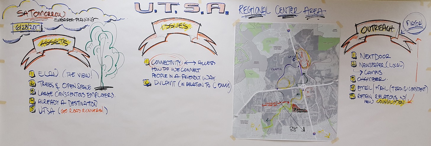
The Planning Team's initial thoughts were recorded on a wall graphic to help inform the plan.
The second Planning Team meeting included a staff presentation of Existing Conditions within the UTSA Area, including findings related to demographics and employment, land use, transportation and mobility, public investment, amenities and access, and natural systems. Review of the Existing Conditions, as well as the previous assets, challenges, and opportunities discussion gave the Planning Team important context for the following "visioning" exercise.
Planning Team members were asked to write their own vision of what the UTSA Area should look like in 20 years. Participants wrote a vision statement and passed it to their neighbor who highlighted 2-3 key words or phrases that appealed to them. Again, the vision statements were passed to the next neighbor, to highlight words that appealed to them. Through this exercise, the Planning Team began to identify visioning themes and prioritize potential vision elements for the UTSA Area. The visioning themes were recorded on the large wall graphic.
Results of Exercise 2 were posted to the Plan website and presented to the Planning Team at the next meeting. This exercise helped inform the draft Plan vision and goals statements.
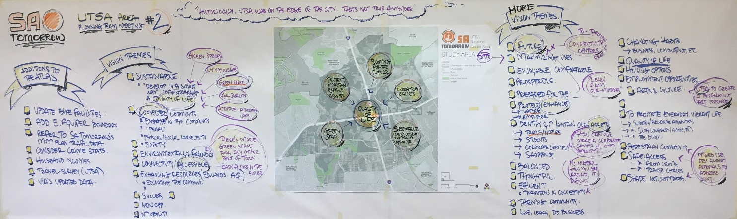
The Planning Team brainstormed ideas that would eventually form the basis of the vision and goals
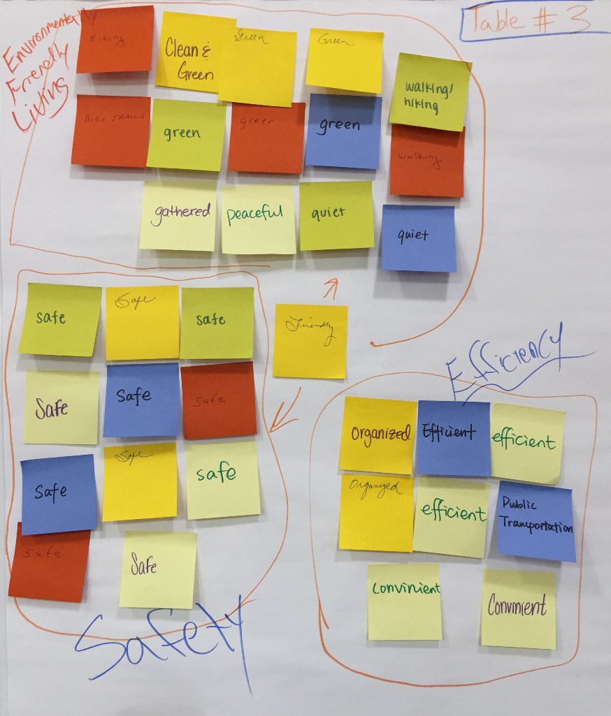
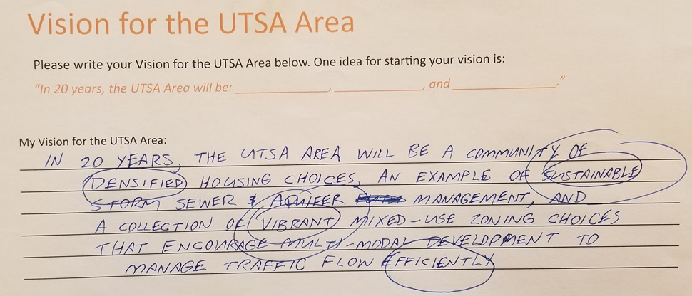
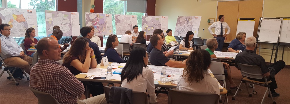
The first UTSA Area Community Meeting was held on September 18, 2017 at the John Igo Branch Library. The objective of this meeting was to introduce the planning process to the broader community, get their input regarding opportunities and challenges, and to further inform the draft vision and goals for the UTSA Area Regional Center Plan. Community members participated in two facilitated small group exercises similar to those previously completed by the Planning Team. First, participants used a map, color-coded stickers, and sticky notes to identify and document the elements in the area that they would like to "Preserve, Add, Remove, or Keep Out" which is known as a PARK exercise. They were then asked to look at all the elements that were identified in the PARK exercise and begin to identify themes and issues. The second exercise asked community members to draft a statement describing how they envision the future of the UTSA Area. Facilitators encouraged community members to think about elements such as housing, connectivity, mobility, parks and open space, shops, restaurants, employment and other amenities. Small group members identified common themes and words amongst the group’s individual vision statements. From these common themes, each group completed a summary of their ideas which was then read aloud by one spokesperson from each group to the entire audience. Results of Exercise 3 were posted to the plan website. These results directly informed the draft vision and goals statement. here. Results of exercise 3 were posted to the plan website. These results directly informed the draft vision and goals statement.
Community Meeting #2 was held on January 29, 2018 at the Phil Hardberger Park Urban Ecology Center, where the revised draft vision and goals were presented, and comments were gathered from various area stakeholders. Participants at the Community Meeting #2 overwhelmingly supported the vision and goals as drafted. These results finalized refinement of the UTSA Area vision and goals statements for the draft Plan unless further public input is received requesting additional changes.
Community members left their comments on the emerging vision and goals for the UTSA Area .
Establishing the Plan Framework and Recommendations
The Plan Framework map includes key physical improvements and strategic concepts that will influence development in the UTSA Area Regional Center. These include priority focus areas for (re)development; pedestrian, bicycle, and street improvements; parks and open space recommendations; and priority areas to encourage mixed-use development.
The UTSA Area Regional Center Plan Framework was developed through a combination of technical analysis and community input. The Framework illustrates and outlines the overall long-term vision for the UTSA Area Regional Center, including areas where new development may be focused, key mobility improvement recommendations, opportunities for more recreation and gathering places, and other “big moves” that will shape the future of the area.
At the beginning of the planning process, the project team developed an in-depth study and analysis of the UTSA Area Regional Center to understand the history, development, and existing conditions of the area. The Planning Team shared their input regarding area assets, opportunities, and challenges to develop a more nuanced understanding of the Regional Center. City staff hosted Community Meetings and workshops to capture the community’s values and priorities from people who live, work, and study in the UTSA Area. Through a series of facilitated work sessions and interactive exercises, the Planning Team and community members provided input and direction that is reflected in the Plan Framework.
Over several months, project staff and the Planning Team worked collaboratively to build upon the Framework, identifying key priorities, improvements, and strategies to shape the Sub-Area Plan, and guide growth, development, and investment in the UTSA Area Regional Center. A series of draft recommendations on several topics were developed for stakeholder feedback and are reflected in the Plan.
At their first meeting, the Planning Team discussed assets, challenges, and opportunities in the UTSA Area. At the second Planning Team meeting, staff presented existing conditions related to demographics and employment, land use, transportation and mobility, public investment, amenities and access, and natural systems within the UTSA Area. These conversations provided a foundation for future discussions related to the Plan Framework. The existing conditions presentation was also shared at the first UTSA Area Community Meeting, where attendees completed a mapping exercise that was incorporated into the framework diagram.
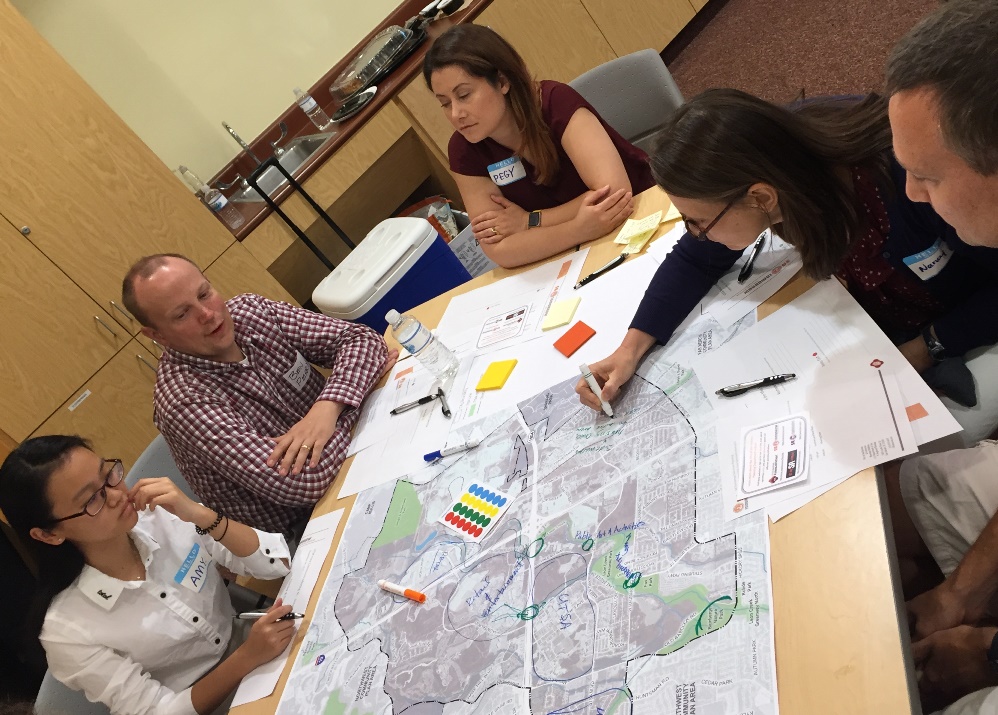
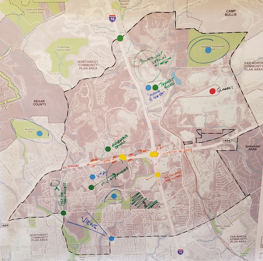
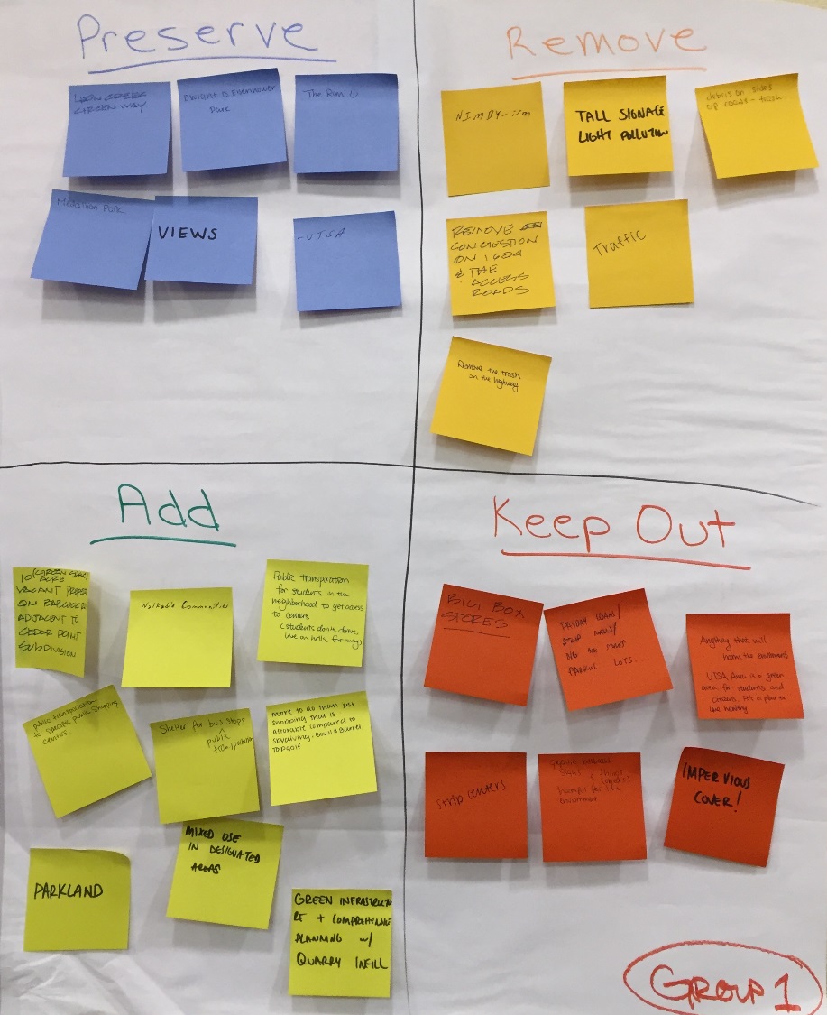
UTSA Area Community Meeting #1 PARK Exercise
The objectives of the third UTSA Area Planning Team meeting included developing key plan concepts such as focus areas and mixed use corridors, as well as identifying potential parks, open space, plazas, trails, and gateway locations. Meeting attendees split into two groups to create their own framework diagrams by drawing these elements on trace paper over the transportation and amenities map. The Planning Team’s diagrams were synthesized by City Staff to create the base for the plan framework diagram.
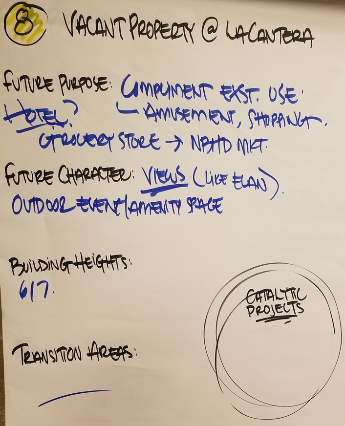
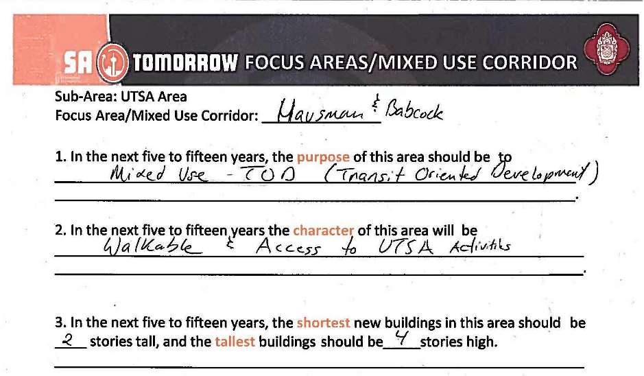
At Planning Team Meeting #4, the group further refined the focus areas by discussing the preferred purpose, future character, appropriate scale, and transitions for focus areas and mixed-use corridors. The groups’ discussions were illustrated on maps, as well as recorded on flip charts. A similar exercise was completed at Community Meeting #2, where participants were able to review the Planning Team’s work and provide their own thoughts.
The subjects of focus areas, mixed-use corridors, and catalytic sites were revisited by the Planning Team at their seventh meeting. The discussion included review of public input received at the second Community Meeting, as well as any additional final thoughts on the proposed focus areas.
UTSA Area Planning Team #4 Discussion Results Example
UTSA Area Community Meeting #2 Feedback Example
Mobility was also discussed at Planning Team Meeting #3, as part of drafting the plan framework. A variety of transportation options were considered for planning the UTSA Area. Trails, transit routes, bicycle routes, streetscape improvements, pedestrian safety, and traffic congestion were discussed as potential means of creating a layered multimodal transportation network.
At Community Meeting #2, participants were asked to complete an activity to help City Staff prioritize different routes for different types of transit. Major corridors were identified on the mobility framework diagram. Participants then voted using stickers with bus, car, and bicycle icons to symbolize what mode of travel they thought needed to be prioritized on each street.
Draft mobility recommendations were presented to the Planning Team at their eighth meeting, along with an updated Mobility Framework Map. Participants discussed the draft recommendations, and clarified the concepts that should be included in the draft Plan.
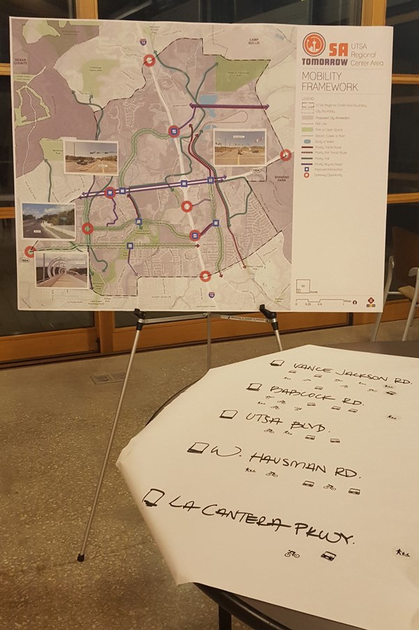
UTSA Area Community Meeting #2 Mobility Exercise
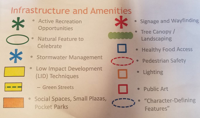
The Planning Team discussed amenities and infrastructure at their seventh meeting. Participants were first briefed by staff on what elements make up a complete neighborhood such as social spaces, healthy access to food, pedestrian safety, stormwater management, low impact development, signage, and public art.
After seeing examples of the elements that create complete neighborhoods, Planning Team members discussed which elements were most critical and should be prioritized to create complete neighborhoods in the UTSA Area. After thoroughly discussing and prioritizing amenities, Planning Team members worked together to create an amenities and infrastructure framework diagram.
At Planning Team Meeting #8, the group revisited their discussion about amenities and infrastructure. Staff presented the diagram that had been created from the previous meeting activity, and led a group discussion to determine if the map and recommendations reflected the consensus of the Planning Team.

UTSA Planning Team Meeting #7 Amenities and Infrastructure Activity
Trace paper map from Meeting #7
The sixth Planning Team meeting was dedicated entirely to the subject of Future Land Use. The meeting began with an overview of the proposed land use classifications to be used throughout San Antonio, the methodology behind the draft maps, and then a presentation of the draft land use map created by City staff. The Planning Team then spent time discussing the draft maps, and their comments and concerns were recorded by staff.
Land Use was revisited at Planning Team Meeting # 7, where staff presented revisions to the land use map based on the comments at the previous meeting. The discussion surrounding revisions to the draft land use map continued at subsequent Planning Team meetings, and included additional land use policy for a longer-term vision of the UTSA Area. Planning Team members and staff had come to a consensus regarding the Future Land Use map and policies.
The draft land use map will be displayed to the public for comment at the third and final Community Meeting in late March, 2019. Participants will be invited to fill out comment cards about the proposed land use designations, recommendations, and strategies. The public will also be invited to review the proposed land use map and submit additional comments through the UTSA Area project website.
Community Meeting #2 included a station related to the topic of housing. Attendees were presented with information about different housing types and were asked to identify where such housing options could be incorporated within the UTSA Area.
The Planning Team also discussed housing concepts and strategies during their fifth meeting. After a presentation regarding existing housing conditions such as accessibility and affordability, the Planning Team members discussed key issues, challenges, opportunities, and potential strategies related to housing in the UTSA Area. Notes from the discussion were recorded on a wall graphic.
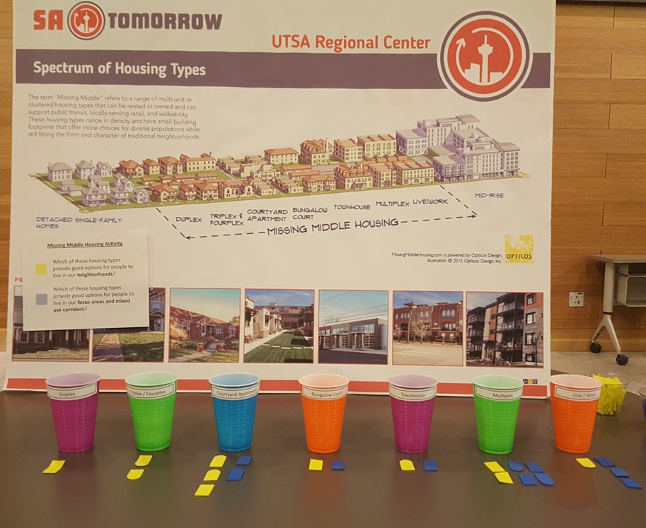
UTSA Area Community Meeting #2 Housing Station and Activity Results
At Planning Team Meeting #5, staff presented additional existing conditions information related to economic development in the UTSA Area such as employment figures and real estate conditions. The group also discussed economic strengths, weaknesses, opportunities, and challenges, as well as potential development policies and implementation strategies. Planning Team members explored key issues and concepts such as major institutions, connections between economic generators, and retention of employers, employees, and students. Notes from the discussion were recorded on a wall graphic.
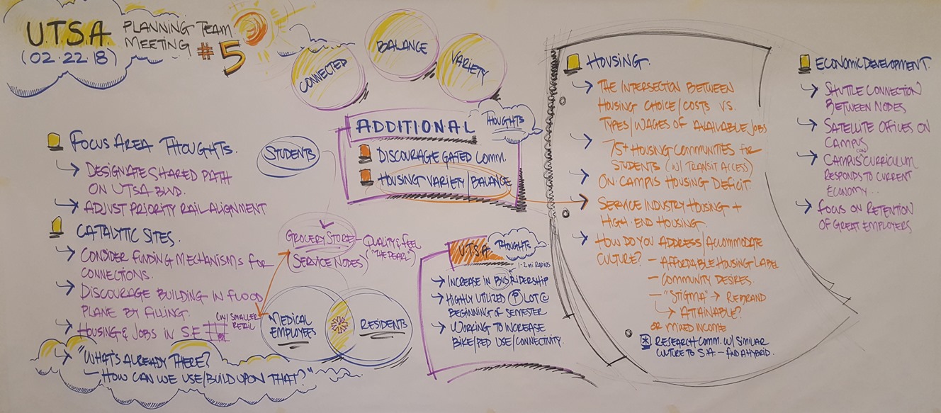
UTSA Area Planning Team Meeting #5 Discussion Notes
Stakeholders
The project team conducted over 100 engagement activities such as interviews, intercept events, and focus groups with stakeholders from the following groups, in addition to conversations with community leaders, small business owners, and individuals not listed below.
Alamo Area Council of Governments (AACOG)
Alamo Area Metropolitan Planning Organization (AAMPO)
American Institute of Architects (AIA)
Big Red Dog
Brown & Ortiz, PC
Castle Hills Forest
Cedar Point Owners Association
City Council District 8
City of San Antonio Aviation Department
City of San Antonio Center City Development and Operations
City of San Antonio Department of Arts and Culture
City of San Antonio Development Services Department
City of San Antonio Economic Development Department
City of San Antonio Fire Department, Station 3529
City of San Antonio Neighborhood and Housing Services Department
City of San Antonio Transportation and Capital Improvements Department
City of San Antonio Metropolitan Health District
City of San Antonio Office of Historic Preservation
City of San Antonio Office of Innovation
City of San Antonio Office of Military Affairs
City of San Antonio Office of Sustainability
City of San Antonio Parks and Recreation Department
City of San Antonio Police Department
City of San Antonio World Heritage Office
Churchill Estates Homes Association
Deerfield Homeowners Association
Dreamhill Estates Neighborhood Association
Edwards Aquifer Authority
Elm Creek Owners Association
Great Northwest Community Improvement Association
Harmony Hills Neighborhood Association
Joint Base San Antonio
Kaufman | Killen
North San Antonio Chamber of Commerce
Northside Neighborhoods for Organized Development (NNOD)
Oak Meadow Homeowners Association, Inc.
Oakland Estates Neighborhood Association
Oakland Heights Homeowners Association
Oakmont Downs Homeowners Association
Pape-Dawson
San Antonio Apartment Association
San Antonio Area Foundation
San Antonio Housing Association
San Antonio River Authority (SARA)
San Antonio Water System (SAWS)
Texas Department of Transportation (TxDOT)
The RIM
The Shops at La Cantera
The Woods of Shavano Community Association
TMI Episcopal School
UT Health San Antonio (UTHSA)
University of Texas at San Antonio (UTSA)
Valero
Vance Jackson Neighborhood Inc.
VIA Metropolitan Transit
WellMed Medical Group