Catalytic Projects
Southwest Corner of UTSA Campus near UTSA Boulevard and Babcock Road
The University of Texas at San Antonio (UTSA) is in the process of updating its Master Plan for their main campus. This, in combination with other nearby public and private investments, presents an opportunity to imagine an edge of the campus that serves students, faculty, and staff, as well as the larger UTSA Area Regional Center population. Development in this area should take advantage of natural greenway corridors and topography, build on the historic development pattern of the campus, and provide a host of public and private amenities.
Southeast Corner of La Cantera
The intersection of I-10 and Loop 1604 presents both challenges and opportunities. In an exploration of what could be possible at the northwest portion of this intersection of freeways, stakeholders imagined new development for the southeast corner of La Cantera that respects the natural landscape and floodplain, takes advantage of opportunities for height and views, links to existing development to the west, and creates new connections to the north and east. It is important to note that the exercise to envision this area was intended to determine a potential solution, but in no way precludes other types and styles of development from occurring there. In fact, the greatest takeaway for stakeholders was an opportunity to articulate important aspects of potential development for the entire Regional Center area.
Introduction
The catalytic sites were selected for more detailed concept design work and their potential investment prioritization. The time frame envisioned for implementing catalytic projects in these areas would typically be three to ten years. The Planning Team identified and discussed areas where investment is desired and feasible and where there is a greater likelihood of return on public investment. The sites were also selected for their applicability to other areas of the Regional Center and ease of transferring development approaches and design intent to other priority sites.
The selection of catalytic project sites was based, in part, on an analysis of where land is available for new development and redevelopment, as well as an assessment of where there is development pressure nearby. In addition, the UTSA Area Regional Center Planning Team chose to focus on areas with land owners that possess a proven track record of successful implementation of quality development that provides public and private benefits.
The two selected sites are very different in both their existing contexts and future vision. The southwest corner of the UTSA Campus has the potential to develop in many ways. While the land should be leveraged to best serve the needs of the University and its students, the conceptual development program allowed stakeholders - including representatives from UTSA - to consider and articulate key objectives and design intent that can apply regardless of the actual development program for the site.
The southeast corner of La Cantera presented a unique opportunity to consider a large piece of undeveloped property that was designated as Regional Mixed Use in the planning process. Intended to include development of a higher intensity and with a diverse mix of uses, the stakeholders that participated in the conceptual design process used the exercise to explore how development that supports the goals of Regional Mixed Use can work within the constraints of the area's dramatic topographic and hydrological constraints.
Catalytic Projects Recommendations
Catalytic Project #1
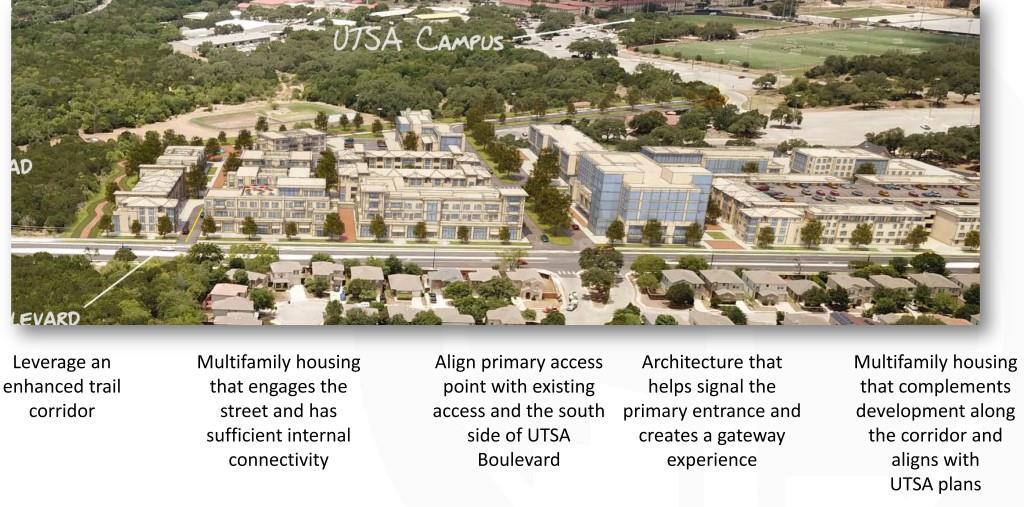
Southwest Corner of UTSA Campus near UTSA Boulevard and Babcock Road
Description
The southwest corner of the UTSA Campus is largely undeveloped today with the exception of older student housing on the eastern portion of the site. Maverick Creek runs through the western edge of the site along Babcock Road, where the property is heavily vegetated and contains a significant drop in elevation. A diagonal axis harkening back to the paseos in the original master plans for the UTSA campus crosses the northern edge of the site.
The intersection of UTSA Boulevard and Babcock Road is becoming more important to the transportation network in this area as more development occurs nearby. Improvements along UTSA Boulevard provide an attractive southern edge to the site.
Vision
The vision for development of the southwest corner of the UTSA Campus combines elements of a main street, a green neighborhood, and trail-oriented development. The Paseo Principal in the interior of the campus could be extended through the northern edge of the site, to honor and leverage strong connections to both the existing campus to the northeast and the new enhanced greenway trail to the southwest. An enhanced butterfly garden and outdoor classroom space near the UTSA Pollinator Garden can punctuate this important connection. An entry gateway including signage and/or public art should be created at the intersection of Babcock Road and UTSA Boulevard. The Maverick Creek and drainage way along the east side of Babcock Road should be used to create a safe and inviting pedestrian and bicycle multi-use pathway for the area while managing stormwater runoff, and protecting the creeks and aquifer. .
Low to medium intensity mixed-use development should:
- Include multifamily housing (likely graduate student or short-term faculty housing) that engages the street and has sufficient internal connectivity;
- Align the primary access point with existing access and development on the south side of UTSA Boulevard;
- Incorporate ground floor commercial space for student- and neighborhood-serving goods, services, dining, and entertainment;
- Tuck small surface parking lots and structured parking throughout the development in order to avoid a small number of very large surface parking lots;
- Include architecture that helps signal the primary entrance and creates a gateway experience into the development and the larger campus; and
- Integrate mixed-use development that complements development along the corridor and aligns with UTSA plans.
Catalytic Project #2
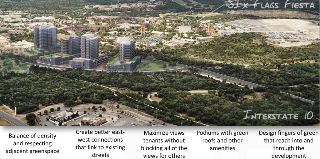
Southeast Corner of La Cantera
Description
The intersection of I-10 and Loop 1604 is a major piece of transportation infrastructure for the UTSA Area Regional Center, the City, and the larger region. In part because of the dramatic topography that begins in this area, and in part due to the constraints created by adjacencies to freeways and quarries, the southeast corner of La Cantera remains undeveloped.
There is limited connectivity to the site from the south and west due to the alignment of the highways and natural constraints. There is a large floodplain covering the southeast portion of the site that was examined and a vision for better trail connectivity through the area that was articulated earlier in the planning process.
Vision
The southeast corner of La Cantera is envisioned to include high intensity mixed-use development serving a local and regional audience. The area is imagined to be a vibrant mixed-use node where people can live, work, and play. Natural topography, vegetation, and drainage are preserved to a significant degree and development is focused on a relatively small footprint in the northwest portion of the area.
Buildings will rise up to at least eight to 12 stories and include space for residential and/or office uses on upper floors, with commercial spaces and structured parking on lower floors. Careful consideration should be given to providing active and attractive facades facing new roadways and existing green space. Rooftops are envisioned to include outdoor recreation and social gathering space, as well as green roof, solar, and other sustainable features.
Regardless of the eventual development program for the site, the overall development should consider the following throughout planning and design.
- Plug into and extend the existing roadway network immediately adjacent to and near the site;
- Take cues from existing multifamily housing adjacent to the catalyst project site with regards to general form and the manner in which the development interacts with the streets;
- Buffer Loop 1604 frontage with active ground floor uses, landscaping and/or parking;
- Balance dense development with smaller footprints, and respect and preserve adjacent green space and necessary flood areas;
- Create better east-west connections that link to existing streets and highways;
- Maximize views for tenants without blocking views for others entirely, by exploring a variety of strategies that may include point or needle towers;
- Integrate podiums within new development with green roofs and other amenities;
- Design fingers of green that connect to existing open space and reach into and through the development;
- Integrate trail and pathway connections through the existing open space as well as to and through the development site; and
- Utilizing stormwater infrastructure to manage runoff to protect the creeks and the aquifer.